Identifying rolling resistance and air resistance simultaneously for an electric truck
This paper provides a detailed description and use case for the Rolldown tool.
Authors: David Hamilton, John Sessions & Christopher Langevin
Published: October 26, 2025
https://doi.org/10.1080/14942119.2025.2561179
Accurately estimating rolling and air resistance is essential for predicting the energy consumption of vehicles. This study presents a field-based approach using a rolldown test to simultaneously determine rolling and air resistance coefficients. Unlike prior methods that frequently used simulations or models, we employ a goal programming methodology to improve precision and evaluate the actual vehicle and environmental conditions. Our methodology was tested using a Class 8 Freightliner eCascadia on a surveyed road section, ensuring controlled conditions for data collection. By analyzing the time–velocity relationship across multiple test runs, we derived resistance coefficients for both loaded and unloaded conditions. The study confirms that rolling resistance is largely independent of velocity at low speeds but exhibits a nonlinear dependency at higher speeds. Additionally, road surface conditions, tire condition, axle configuration, aerodynamic properties, and weather conditions significantly impact resistance values, emphasizing the need for real-world testing rather than relying solely on standardized projections. Our results align with existing literature while demonstrating the efficacy of the goal programming approach in refining resistance estimates. This work contributes to improved vehicle energy modeling, offering practical insights for fleet operators and policymakers seeking accurate energy consumption predictions for electric trucks operating under varying environmental conditions.
Forestry electric vehicle energy routing and mapping GIS tool

This paper provides a detailed description and use case for the FEVER tool.
Authors: David Hamilton, Victoria Diederichs & John Sessions
Published: May 23, 2024
https://doi.org/10.1080/14942119.2024.2353501
Abstract: In the United States, new laws and regulations in several states require increasing percentages of vehicles produced in the future to be zero emission to address climate-related issues. Manufacturers are producing more Electric Vehicles (EVs), but potential customers are hesitant to adopt EVs due to range anxiety. Log truck owners are particularly hesitant to invest in electric log trucks (ELTs) due to forest harvest operations remote nature. However, regenerative braking utilizing gravitational potential energy provides the opportunity to increase the range of ELTs. This manuscript presents the workflow for calculating and mapping energy transportation cost on an ELT using a GIS-enabled tool and demonstrates the tool’s applicability through a case study. The study area, the McDonald Dunn Research Forest, included 5,607 ha of forest stands partitioned into 357 harvest polygons averaging 15.7 ha, 326 harvest landings and 295 km of road. Using remotely sensed data from the study site, the tool digitalizes the wood supply chain and optimizes routing based on minimum energy expenditure, providing results such as trip energy cost, distance, and time. The results show the tools forest operations planning potential, applicability as a GIS navigation system, and provides EV buyers with a tool to make informed decisions when investing in technology that could combat climate-related issues. EV adoption will reduce reliance on fossil fuels and potentially ameliorate other environmental problems.
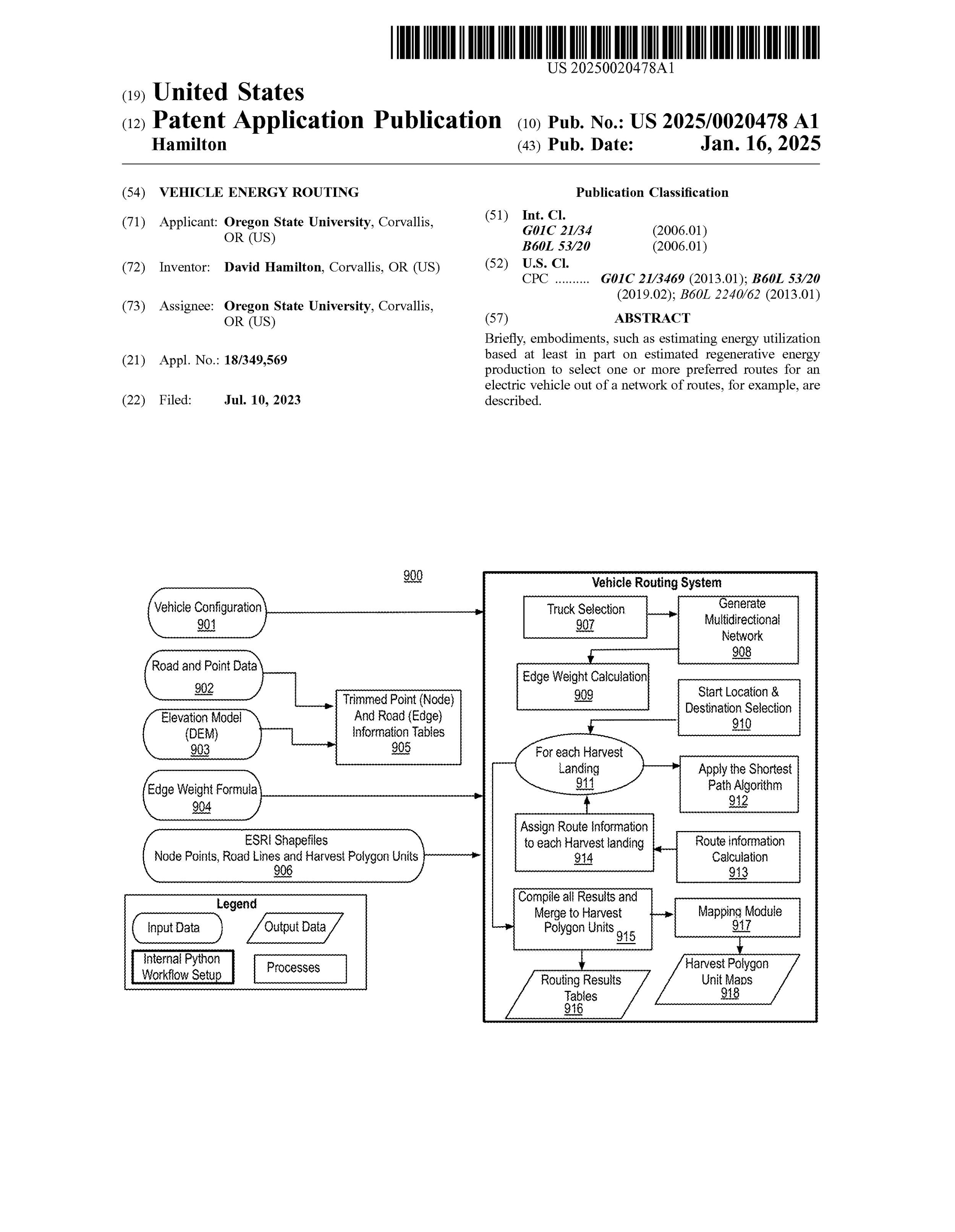
Vehicle Energy Routing Patent
Publication number: 2025/0020478 A1
Abstract: Briefly, embodiments, such as estimating energy utilization based at least in part on estimated regenerative energy production to select one or more preferred routes for an electric vehicle out of a network of routes, for example, are described.
Filed: July 10, 2023
Publication date: January 16, 2025
Applicant: Oregon State University
A312 KERR ADMINISTRATION BUILDING
CORVALLIS, OREGON 97331
Inventor: David Hamilton
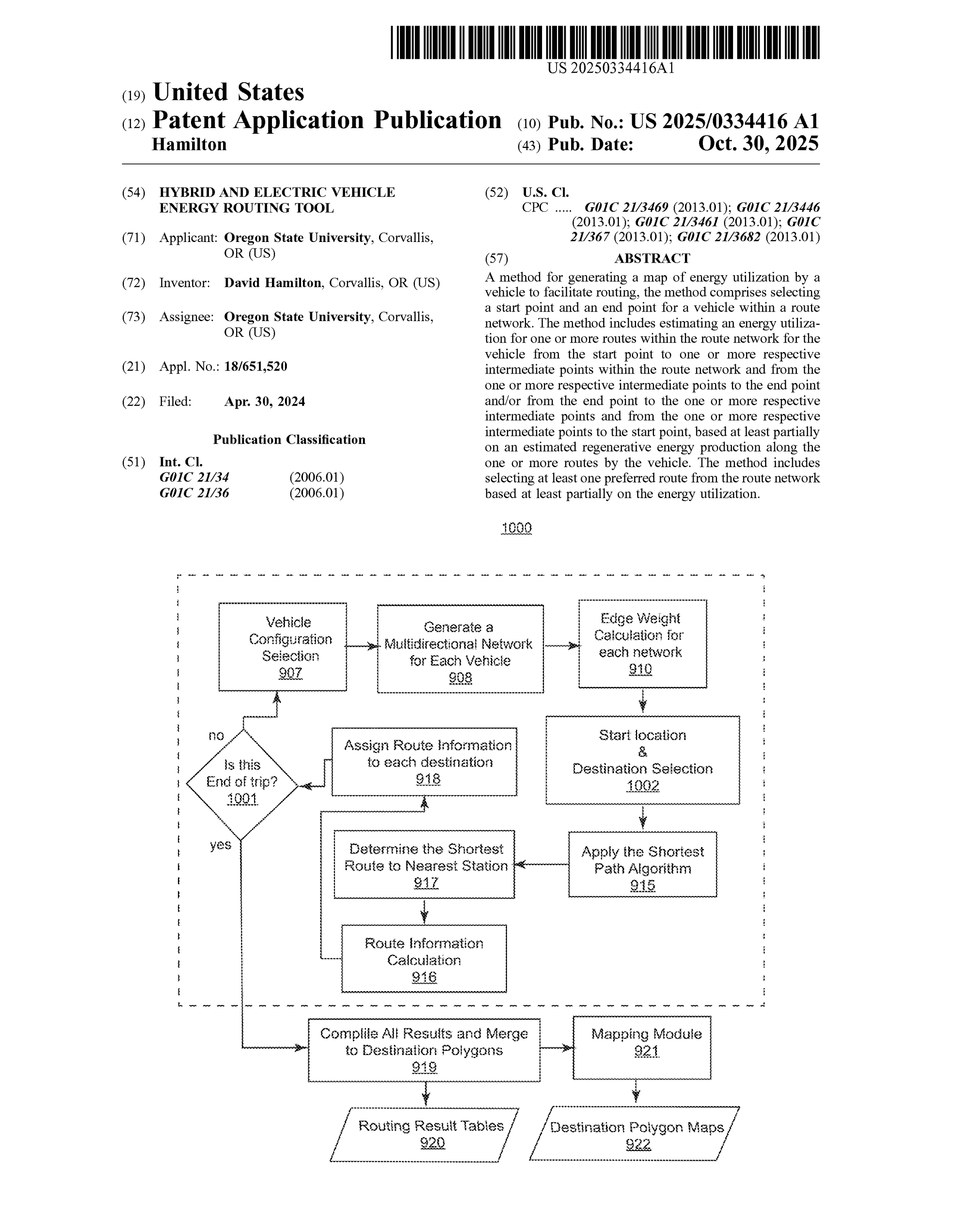
Hybrid and Electric Vehicle Energy Routing Patent
Publication number: 2025/0334416 A1
Abstract: A method for generating a map of energy utilization by a vehicle to facilitate routing, the method comprises selecting a start point and an end point for a vehicle within a route network. The method includes estimating an energy utilization for one or more routes within the route network for the vehicle from the start point to one or more respective intermediate points within the route network and from the one or more respective intermediate points to the end point and/or from the end point to the one or more respective intermediate points and from the one or more respective intermediate points to the start point, based at least partially on an estimated regenerative energy production along the one or more routes by the vehicle. The method includes selecting at least one preferred route from the route network based at least partially on the energy utilization.
Filed: April 30, 2024
Publication date: October 30, 2025
Applicant: Oregon State University
A312 KERR ADMINISTRATION BUILDING
CORVALLIS, OREGON 97331
Inventor: David Hamilton
Developing Heavy Duty Electric Vehicle Energy Transportation Cost Mapping

This conference paper was presented at the 18th International Forum for Heavy Vehicle Transport & Technology and was produced as a deliverable for the DOE SBIR grant supporting the development of the Mauka Energy FEVER Tool.
Authors: David Hamilton, Christopher Langevin, John Sessions & Victoria Diederichs
Presented: May 28, 2025
Abstract: Heavy-duty transportation plays a critical role in global logistics but is also a significant contributor to greenhouse gas emissions. Transitioning this sector to electric vehicles (EVs) presents unique challenges, including high upfront costs, operational risks, and the complexity of energy management. The Forestry Electric Vehicle Energy Routing (FEVER) tool offers a solution by delivering energy-optimized routing tailored for heavy-duty EVs. FEVER’s innovative approach incorporates regenerative braking, load variability, and terrain-specific dynamics to provide precise energy consumption forecasts. Field trials are planned to validate its practical applicability, demonstrating how FEVER minimizes energy usage, reduces operational costs, and instills confidence in EV technology for heavy-duty applications. This tool represents a critical advancement toward reducing carbon emissions in the heavy vehicle sector, aligning with global sustainability goals and the future of transport.